
Beryl Spring
| Beryl Spring | |
|---|---|
 Beryl Spring | |
 | |
| Location | Gibbon Geyser Basin, Yellowstone National Park, Park County, Wyoming |
| Coordinates | 44°40′45″N 110°44′49″W / 44.6791015°N 110.7468765°W[1] |
| Elevation | 7,398 feet (2,255 m)[2] |
| Type | Hot Spring |
| Eruption height | 1-4 feet |
| Frequency | Near constant |
| Duration | Near constant |
| Temperature | 83.3 °C (181.9 °F)[1] |
Beryl Spring is a hot spring in the Gibbon Geyser Basin of Yellowstone National Park in the United States. It is a large superheated pool, and boils up to a height of 4 feet.
One of the hottest springs in Yellowstone, averaging 196 °F (91 °C).,[3] Beryl Spring was named by the U.S. Geological Survey Hague party in 1883 for the blue-green color which reminded a party member of the gemstone beryl.[4]
Images of Beryl Spring
-
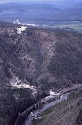 Aerial view of Beryl Spring, 2001
 -
Beryl spring bubbling, July 2019

References
- ^ a b "Beryl Spring". Yellowstone Geothermal Features Database. Montana State University.
- ^ "Beryl Spring". Geographic Names Information System. United States Geological Survey, United States Department of the Interior.
- ^ Fournier, R. O.; Weltman, U.; Counce, D.; White, L. D.; Janik, C. J. (2002). "Results Of Weekly Chemical And Isotopic Monitoring Of Selected Springs In Norris Geyser Basin, Yellowstone National Park During June-September, 1995" (PDF). U.S. Department of the Interior & U.S. Geological Survey. Archived from the original (PDF) on 2011-06-08.
- ^ "Beryl Spring". National Park Service. Archived from the original on 2004-04-30.
Yellowstone National Park - Norris and Madison | ||
|---|---|---|
Geothermal features, historic structures and other attractions in the Norris and Madison Junction areas | ||
| Norris Geyser Basin |  | |
| Gibbon Geyser Basin | ||
| Structures and history | ||
| Geography and geology | ||
| ||